INDIAN RIVER RIDGE / SOUTH INDIAN RIVER DRIVE
HISTORY
By
R.E. (Rick) Langdon
Historian - Indian River Drive Freeholders, Inc.
Member - St. Lucie Historical Society
Anglo-American occupation and a sense of community identity along Indian
River Ridge and “The Drive” stretches back nearly as far as Florida history
exists. Florida was purchased by the United States July 17, 1821
and St. John’s County formed which included most of East Florida.
Prior to our current County jurisdiction, this area was within the bounds
of St. John’s County (1821 – 1824), Mosquito County (1824 – 1844), St.
Lucia County (1844 – 1855), renamed Brevard County (1855 – 1905), and finally
became St. Lucie County – Florida’s 46th County on May 24, 1905.
Florida was granted statehood on March 5, 1845.
Pre and early Florida history yields occupation in this area by the
Ais, Creek, and Alachua Indians which by the mid 1800’s came to be known
as “Seminoles”. The Mid 1800’s marked the start of significant occupation
in the area by Anglo-Americans. An Army outpost, Ft. Pierce, was
located about 4 miles south of the (natural) inlet thru “Hutchinson Island”
and manned from 1838 – 1842 during the period of the second Seminole War.
This fort was decommissioned in 1842 and a second outpost, Fort Capron, located
near the current St. Lucie Village – north of the city of Ft. Pierce was
manned for the period 1849 – 1858 during the period of the third Seminole
War.
The year 1842 marks the start of a significant period in the development
and occupation of this “Indian River Ridge” area. To encourage settlement,
and in an attempt to free the federal government from the burden of providing
and maintaining troops in the area, the U.S. Government on August 4, 1842
passed the “Armed Occupation Act” - which applied to Florida only, and
was the predessor to "the Homestead act" of 1862.. This act, in order
to encourage settlement and provide for a ready civilian militia to defend
their lands - provided for the grant of 160 Acres to settlers willing
to occupy, erect a fit habitat and cultivate at least 5 acres of their
lands in southeastern Florida for a minimum period of 5 years. Additional
provisions of this Act provided that these homesteads be no closer than
2 miles from existing forts. Permit Number 1 under this act was
granted to Dr. Fredrick Wheedon and included lands containing the only existing
structures in the region, the now deactivated Ft. Pierce. Unfortunately
this advantage, of having the deactivated fort on his lands, was short
lived. The buildings of Fort Pierce burned in December, 1843.
As a result of this inducement, pioneer settlers did arrive in the area,
which was known as The Indian River Colony. This colony ultimately
consisted of claims and grants to about 40 families stretching along the
Indian River from Barkers Bluff, near Sebastian at the north to almost to
Ft. Jupiter at the south. Locally, along our Indian River Ridge area,
this Armed Occupation Act settlement was known as the Susanna settlement
which consisted of 8 homesteads stretching along the west bank of the Indian
river from the Davis grant south thru areas to be known later as the Eldred
and Ankona communities.
From an article - How and by Whom Gilbert’s Bar was Opened in 1844
by Professor William Henry Peck – “The Florida Star”, May 5, 1886
In the summer of 1844 the leading settlers of the Indian River
Country became convinced that it was vitally necessary … to open Gilbert’s
Bar, which had been closed for many years. The only settlers at
that date, along the entire stretch of Indian River, from Gilbert’s Bar
nearly to New Smyrna, lived on the west shore of St. Lucie Sound opposite
Hutchinson’s Island, below Indian River Inlet. From the mouth of
St Lucie River, southward, as far as Key Biscayne Bay, there were no settlers.
Unfortunately for many of these homesteaders, an Indian massacre of
“Trader Barker”, who had a store in the area and allegedly on several occasions
cheated them in their trades (sold them defective gunpowder) raised fears
of a general Indian uprising and the Susanna settlers made a hasty retreat
to the relative safety of St. Augustine. This abandonment of their
claims took place in August 1849. The 1850
census reflects this, most civilians having departed the area and not
yet returned. This enumeration shows a total population, in December
1850, of 112 at 22 dwellings in this "division" of the census, 49 of which
were Soldiers barracked at Ft. Capron.
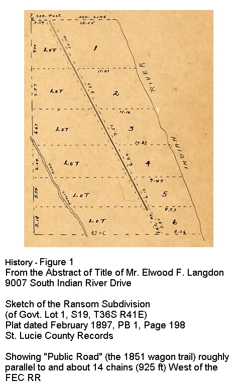
In January 1851, the Florida Legislature appropriated $1,000 to build
a wagon trail (Military Trail) from the Fort located at Biscayne Bay to
Fort Capron across from the St. Lucie Inlet on the Indian River. (See History - Figure 1)
Little evidence of these earliest homesteads exists, except in
the initial land records for the area. In preparation for
the transfer of lands from public to private hands, the General Land Office
survey of the lands including our Indian River Ridge area were performed
during the period 1844 – 1853. Two parcels, preexisting claims and
grants under this Armed Occupation Act were noted but “excluded” from this
survey of public lands available for sale. Near the northern end
of our proposed town limits is The W.B. Davis Permit lands, a 143.77 Acre
grant under this act, which extends from about 3553 to 4477 South Indian
River Drive. The only known artifact from this settlement exists
in the form of a Coquina Rock fireplace, with the marking 1844 inscribed,
at 4111 SIRD. Near the south end of our proposed town limits is the
James S. Grant Permit lands, a 158.81 Acre grant which extends from about
12623 to 13459 South Indian River Drive.
All of the initial recordings for lands along Indian River Ridge were
either in the form of U.S. Government Patent deeds (for “good lands”) or
State of Florida Deeds for lands transferred from the Federal Government
to the State of Florida and subsequently sold by the state. Under
the Act of September 28, 1850, (“The Swamplands Act”) lands identified as
swamp and overflowed lands unfit for cultivation was granted to the States.
Once accepted by the State, the Federal Government had no further jurisdiction
over the parcels.
An item of interest with respect to some of the State deeded lands
in the Savannas is that they are part of a sale, in June 1881, by
the cash strapped State of Florida, to Hamilton Diston of Philadelphia
and his associates for 4 million acres (of “Swamplands”) for 1 million
dollars … 25 cents per acre. At the time, the typical price for these
government lands was $1.25 per acre.
The primary Government land office responsible for the disposition
of these lands was located in St. Augustine. All, except one, of the initial
deeds located for the lands of Indian River Ridge, referred to lands located
in Brevard County, Florida. The lone exception, identifying a specific
“place” is for lands purchased in April 1889 at the south end of our proposed
town lands by Joseph Howard LeTourneau from Eden, Brevard County, Florida.
Lucie Richards, the future wife of Joseph Howard LeTourneau, is the daughter
of Capt. Thomas Edward Richards, one our earliest pioneer families. He
moved here in 1879, established one of the areas earliest successful Pineapple
Plantations and named the community known as Eden, for it’s similarity
to The Garden of Eden. A book of her letters about pioneer life in
South Florida 1880 – 1888 has been compiled and published by Raymond Richards
Brown, as Memories of Eden. The Richard’s Family also operated
a popular and successful boarding house in their home named Eden Grove.
Unfortunately this historic home was destroyed by fire in 1989. Capt
Thomas Richards, his wife Rebecca, and Lucie’s brother Will, one of 9 brothers
and sisters, are buried in a family cemetery, Eden Cemetery, near the north
end of the Richards Plantation lands at 12767 South Indian River Drive.
The period 1880 through the 1890’s marks the start of continuous occupation
and development of the Indian River Ridge area. This period also
includes two of the most significant events in the opening of South Florida
for habitation and development. The first of these was recorded
in September 1890 when the State of Florida granted to the Florida Coast
Line Canal and Transportation Company (a Henry Morrison Flagler company)
36,103.03 Acres from Lands of the Internal Improvement Trust Fund of the
State for the completion of what would become a segment of the Intracoastal
Waterway from St. Augustine to Biscayne Bay, a distance of 134 ½
miles - dredged to a 5’ depth x 50’ width at MLW.
Also during this time period, the state was granting to various Railroad
companies lands from the Internal Improvement Trust Fund at rates ranging
from 6,000 to 20,000 acres per mile of railway constructed and placed
into operation. One of the largest single grants noted was a grant
in 1885 to the "Florida Southern Railway Company" of 1,592,018 and
64/100 acres (of which 819,997 and 54/100 acres were in the present St.
Lucie County) for the completion of 165.26 miles of road (at 10,000 acres
per mile) from Gainsville to the Withlacoochee River in Hernando County.
Through many mergers and acquisitions these became grant lands of Henry
Flagler and his Florida East Coast Railway. We agonize now about economic
incentives extended to business for development … in the late 1800’s the
State of Florida was quite literally “giving away the state” to open it
up.
This led to the second, and probably the most significant of the events
opening up South Florida – the extension by Henry Flagler of his Florida
East Coast Railway from St. Augustine to West Palm Beach in the period
1892 – 1894, on to Miami in 1896 and ultimately to Key West in 1912 with
steamship connections from Miami to Nassau and from Key West to Havana.
The construction of the FEC Railway, although initially providing greatly
increased access to the northern markets for South Florida Pineapples,
was also a significant contributor, combined with fungus problems and freezes,
in the demise of the our Pineapple Plantations following the removal of protective
tariffs on “Pines” and greatly increased importation of Pineapples from Cuba
and the Bahamas.
The Railroad arrived in Ft. Pierce in January 1894 and West Palm Beach
in March of the same year. Right of Way acquisitions were being
made through "our back yards" in the period May 1893 through about November
1893. The railway thru our backyards limited the ability for development
west of the railroad even though most parcels and subdivision of parcels
along this stretch of the Indian River Ridge extended from the West bank
of the Indian River (also referred to as the St. Lucie Sound or Indian River
Lagoon) westward to the Eastern limits of the Savannas, a natural boundary
separating development along the Indian River / Savannas Ridge from development
to take place west of the Savannas. From a1915 FEC Railway map it
appears that station stops existed in this area at St. Lucie, Ft. Pierce,
White City, Eldred, Walton, Eden, Jensen, and Stuart. Around 1906 the
White City Depot name was (briefly) changed to Carson at the request to the
FEC from Mr. M.E. Card and Mr. Bill Robinson, big shippers on the Railroad,
by taking “Car” out of Card and “son” out of Robinson thus making Carson.
The local people did not like this at all and resented the name change,
some enough to move their shipping point north to the Ft. Pierce Depot.
Another of the early settlers to the Indian River Ridge area was Elon
Eldred who arrived here around 1879 from Carrolton, Illinois – also with
the intent, and success, in establishing a Pineapple plantation in the area
south of Midway Road - which would become the location of the White City
Depot of the FEC Railway. The Eldred House was built in 1893 at what
is now 6101 South Indian River Drive. Mrs. Marial Minton, a direct descendent,
currently resides at this location and has in her possession a framed copy
of the July 24, 1895 deed from Hal S. Thomas and Julia Eldred Thomas to the
Board of County Commissioners of Brevard County, selling 13 ¼
acres (for one dollar) thru the Eldred lands “along the Indian River on top
of the bluff and about 20 feet back from the top thereof” for the purpose
of constructing what is now South Indian River Drive.
From an article by John Pennekamp in the “Herald” – 9/16/68
Comments Wenzel J Schubert, a “native born, old time East Florida
Cracker”…Seventy years ago (1898) I stood on Grandfather Tancre’s front
porch at Ankona … and watched a gang of laborers chopping down and grubbing
out several fine old trees as they cut the new “county road” right across
the middle of our front yard. This narrow, single lane, dirt road
that tunneled through the dense river bank hammock growth was Florida’s first
East Coast Throughway. That Fall, Brevard County finished it as far
south as Stuart, where Dade County took over and cut it eventually through
to Miami and Homestead.
Over the years since it’s initial cut thru as a “sand trail” the road
through our front yards has been variously identified as Riverside Drive,
The Dixie Highway, U.S. Highway 1 (prior to construction of the “new” U.S.
1 approximately 4 miles inland), State Road 707, and currently County Road
707 and South Indian River Drive.
From the earliest days, speeding on The Drive has been, and remains,
a major concern of residents.
From “The St. Lucie County Tribune”, March 21, 1913
We second the Ankona correspondent’s efforts to draw the attention
of the proper authorities to the reckless use of automobiles on Riverside
Drive. A pedestrian, bicycle, or horse and wagon have no rights
at all, as far as some of them are concerned, and that Fort Pierce man
who drives so recklessly at night without lights need to be severely dealt
with. One of our most conservative men said an unlighted car passed
down the road one night last week, going a mile a minute. It is a
shame and an outrage and should not be allowed. To the credit of
most of the owners of cars we will say that they are uniformly courteous
and gentlemanly, but there are a few who are aching to get into trouble and
will probably succeed.
From the days of the earliest homesteaders and settlers along our Indian
River Ridge there appears to have existed a strong sense of community
and community identity. This sense of self identity and community was
quite obviously reinforced by our natural boundaries
As time passed, and development along the Indian River Ridge progressed,
local community identity was reinforced by the establishment of post offices
located at Eden (7 July 1882 – 31 March 1923), Tibbals (28 April 1899
… renamed Walton 18 March 1907 as a “marketing” tool in honor of Isacc
Walton to stress the opportunities for fishing and hunting in the area
and which continued to be operated as the Walton Post Office until 30 June
1944), Ankona (named for the Ankeny Family, 29 May 1886 – 31 August 1953),
and Eldred (23 August 1902 – 11 November 1942). Postal service for
our area has now shifted to the Ft. Pierce PO for properties located North
of Walton Rd. and to the Jensen Beach PO for those living south of Walton.
In conjunction with the decline of pineapple farming along the Indian
River Ridge area, The FEC railway was, in the 1910’s, abandoning, tearing
down, or disposing of many of the early shipping Depots along their line
including all the early depots in our area – the White City, Eldred, Walton,
and Eden Depots. In 1912, the Walton Depot was acquired by St.
Lucie County and moved on rollers from its original location immediately
north of Walton Road to its present location at the corner of Ridge Ave
and Harris Street in the Walton Community. This remains one of only
a very few of the early FEC Depots that still exist – anywhere.
From 1912 thru the late 1990’s, this “Walton Hall” has been the center of
community identity and activity for the residents of the Indian River Ridge
area. In the late 1990’s, the County shifted jurisdiction over this,
and other similar “community center” assets of the County to it’s Department
of Leisure Services – which implemented rental fees for their use by the
communities and groups which had enjoyed the free public use of these facilities,
as a County / Community service for nearly 90 years.
Despite the shift in our postal service and the “taking” of our community
center, a strong sense of local community identity and pride remains.
Development of properties within the limits of our proposed Town of
Indian River Ridge proceeded slowly in the period “pre 1900” through the
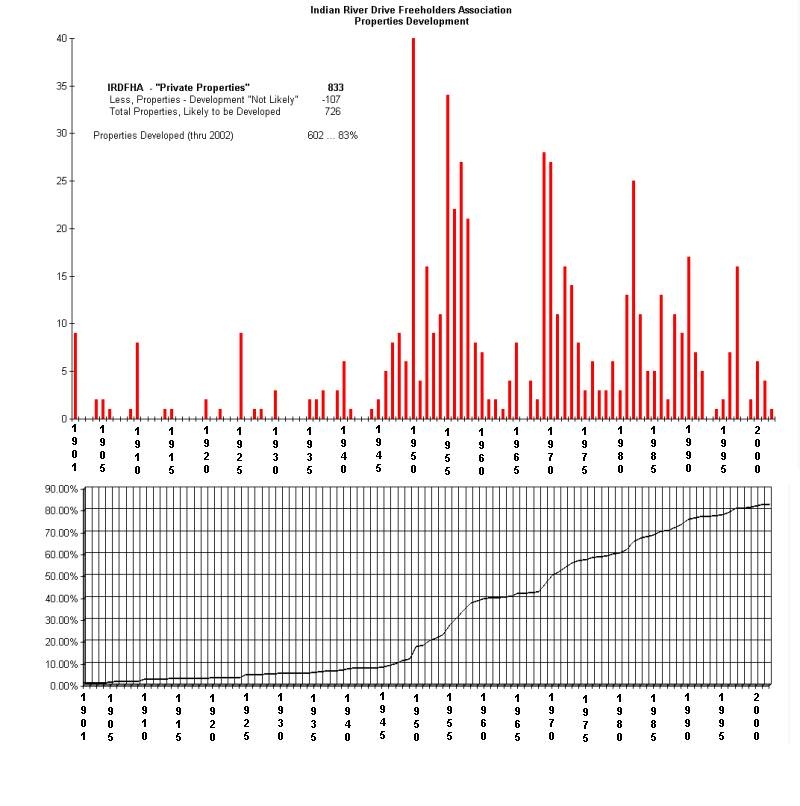
mid to late 1940’s (see History – Figure 2).
In 1947, based on the current parceling of properties within the proposed
limits of Indian River Ridge, occupation had reached approximately 10%.
However, in anticipation of coming development, the period 1938 – 1947 represents
a landmark period along “The Drive”.
During this period, The Indian River Drive Freeholders Association
was organized. The primary purpose of this organization was to work toward
obtaining passage of legislation authorizing the establishment of “local
initiative zoning districts”. These efforts resulted in the passage
of AN ACT in the Florida Legislature (Chapter 24865 No. 1251, House Bill
No. 676, 9 pages) - which Empowers the Board of County Commissioners of St.
Lucie County to “.... provide for the establishment of zoning districts within
the unincorporated areas of the County ... by petition of a majority of
the land owners within such proposed zoning district". The final page
of this ACT includes the notation - "Became a law without the Governor's
approval, Filed in Office Secretary of State May 28, 1947".
The passing of this Act, and petition by the residents along The Drive,
led to a Resolution by the Board of County Commissioners of St. Lucie County
which established "The Indian River Drive Zoning District" filed - December
7, 1947, Deed Book 139, Page 334, St. Lucie County Records. Coverage
of this district extended from the City Limits of Ft. Pierce south to
what is now 10151 SIRD (just north of the private road known as Indian
River Lane), and west to the FEC Railroad. The primary purpose of
our residents in creating this zoning district was the retention of the
rural, single family residential character of “The Drive”. It is
believed that this was a “first” in Florida and the predecessor of Acts
which followed addressing the areas of zoning regulation and land use planning
within unincorporated portions of the counties throughout Florida.
(See - Various Historic and Informational
Documents)
On May 10, 1961 - by Act of the Florida Legislature, HB 953 (Filed
in the official Records of St. Lucie County, OR Book 10 Pages 1-37) the
City of Port St. Lucie was created. With one exception the eastern
boundaries of this new town generally followed existing government land
survey lines roughly describing the center of the Savannas, our western
natural boundary. The sole original exception to this was a “finger”
which extended eastward to the west bank of the Indian River flanking, on
the north and south, the county right-of-way of Walton Road. Even
long time residents along The Drive were unaware of this “finger” of Port
St. Lucie which bisected our community along Indian River Ridge. No
“City Limits” signs have ever been posted along South Indian River Drive.
It was “thought” by our residents that this was a late 1990’s annexation
to accommodate an effort to bridge the Indian River Lagoon and extend Walton
Road east to South Hutchinson Island which was opposed by the Indian River
Drive Freeholders in continued defense of the character of The Drive and
our community.
In 1973, in a legal, but unusually short time period, Port St. Lucie,
by ordinance. annexed properties reaching eastward across the Indian River
Ridge to the bank of the Indian River. This was an annexation of
the parcels north of the Walton Community, commonly referred to as the
Walton Woods or the Walton Scrub – with
the exception of the Jill & Kim Brownie parcel on the riverbank
in the “center” of the land annexed.
May 14, 1973: Petition for annexation
May 22, 1973: Petition for rezoning upon annexation
June 26, 1973: Public hearing
June 26, 1973: Both petitions approved, annexation ordinance 73-15
passed
The purpose for this request for annexation and rezoning was for the
development of a large block of high density apartments and condominiums.
This was vigorously opposed by residents along Indian River Ridge and the
IRD Freeholders Association who had gotten wind of the effort and opposed
it in front of the St. Lucie County Zoning Board. We had no “voice”
however in opposing the action by the City of Port St. Lucie who had, by
act and charter, the right to annexation by petition from the land owner,
and St. Lucie County zoning control was by-passed. The petition for
annexation and rezoning was approved despite petitions signed by practically
every resident of The Drive, begging Port St. Lucie not to do this to us.
Subsequent to this annexation, the developer attempted to build a causeway
off of Walton Road through the Savannas to access this property from the
West. However, this was enjoined by the State Department of
environmental Regulation and the developer ordered by the court to restore
the Savannas to their original condition. He didn’t. After
much public outcry, General Development Corporation – the developers and
“founders” of the City of Port St. Lucie stepped in and did the restoration
as a “public service”. Since this aborted attempt at high density
development these lands have been acquired by The Florida Inland Navigation
District – as a potential dredge spoil site for maintenance dredging of
the Intracoastal Waterway, and by St. Lucie County – for use as a future
Indian Riverside Park (?).
In 1974, following this experience – of having little or no control
over our destiny - a proposed Charter for the “Town of Ankona” was
drafted and public hearings held at the Walton Community Hall on January
24th and 31st. These early efforts were reported in the “News
Tribune” in articles dated January 19 and 20, 1974. Unfortunately,
this effort faded away for unknown reasons.
Through the 1960’s and early 1970’s, public concern and awareness of
the value of our natural resources increased. Supported by the efforts
of the Indian River Drive Freeholders, and many others, these concerns
culminated in the creation of Aquatic Preserve A-10, aka "The Jensen Beach
to Jupiter Inlet Aquatic Preserve" (of the Indian River Lagoon).
This was recorded by Resolution of the State of Florida board of Trustees
of the Internal Improvement Trust Fund dated August 29, 1973, Filed September
24, 1973, Register #264312, and recorded in the Official Records of
St. Lucie County in OR Book 218 Page 2865.
Also, during this time period, the Board of Trustees of the Internal
Improvement Trust fund of the State of Florida commenced the reacquisition
of private lands in the Savannas, which were sold by the state in the
mid to late 1800’s, for the creation of the Savannas State Preserve.
The first recorded reacquisition of these lands in the Indian River Ridge
area was recorded April 1, 1976 in the gift of a .05 Acre parcel lying west
of the FEC Railway behind Sheriden Lane. Reacquisition by the state
of lands west of the FEC Railways for this Savannas State Preserve is a
continuing effort, the most recent being the repurchase of four parcels
totaling 87.49 Acres, south of Midway Road, for $650,000 recorded March
19, 2003.
(See
- Various Historic and Informational Documents)
For the past 66 years, The Indian River Drive Freeholders Association
has been the public voice and social focus for residents along The Drive.
Thru the years it has undergone several reorganizations, levels of activity,
and levels of participation. However, the association has remained
true to its original goal of protecting and preserving the unique character
of the drive and the continued health and preservation of our natural boundaries
- The Indian River and The Savannas. The present “character” of
the drive can well be credited to the associations efforts in retaining
The Drive in its rural, two lane (narrow and winding) state flanked on
the west with single family residential development. The time over
which Indian River Ridge has developed, slow and steady over a period of
125 years, along with its continued rural nature (private wells and individual
septic tanks/drain fields) also contributes greatly to the character of
our community and the diversity of our residences – character and diversity
appreciated by new residents and jealously guarded by long time residents.
Current efforts toward creating our own town grow from renewed concerns
of annexation by our member residents coupled with the desire to have a
much stronger – municipal – voice in future development along the Indian
River Ridge. In October 2000 the Indian River Drive Freeholders, Inc.
authorized the formation of an Incorporation Committee to study the feasibility
of incorporating our community. We pray that the effort is successful
and that we may soon join our similar neighbor to the north – St. Lucie
Village – and become the 4th municipality incorporated in St. Lucie County,
Florida.