Indian River Drive - PARADISE (Ft. Pierce Tribune
Article) and section Index page
MAPS Index Page
HISTORY Index Page
Prepared by Rick Langdon
Historian - Indian River Drive Freeholders
Association

Rick
Home
"NEW" - 21 April 2006 / "Revised"
- 27 April 2006
1895 - 2006
THE DRIVE - That ribbon of asphalt thru
our front yards
--- First, "the bottom line" ---
Most of the segment of South Indian River Drive
which remains within unincorporated St. Lucie County is "undefined"
with respect to roadway alignment and right of way width
- except as defined specifically within individual property descriptions,
recorded plats, formal conveyance, or other instruments.
That is, it "may" have been surveyed, but it has not been mapped on
a "Roadway Maintenance Map" as defined by Florida Statute.
--- Background that builds to where we are now ---
July 17, 1821 - Florida purchased from Spain
by the United States and became a US Territory, St. Johns
County formed which included most of
"East Florida"
December 29, 1824 - Mosquito County formed
- basically the central third of East Florida
February 4, 1836 - Dade County (Florida's 19th)
formed - basically all of South-East Florida
1835-1842 - The period of "The Second Seminole
War"
1838 - Ft. Pierce (The fortification) established
on the bank of the Indian River, South of Ft. Capron
August 4, 1842 - The "Armed Occupation Act"
passed. This was intended to encourage settlement within
Florida and provide for a source of ready militia, if necessary.
It offered title to 160 acres of land and a years rations to those
willing to settle on and cultivate a minimum of 5 acres for a period
of 5 years.
This Act prompted some scattered settlement
along the banks of the Indian River including several homesteads
in this area in what was called the "Susanna" Settlement.
Remains of a Coquina Rock Fireplace inscribed "1844", part of
the oldest existing structure in St. Lucie County are still visible
at 4111 South Indian River Drive. This was part of the William
B. Davis Permit lands, one of Two Armed Occupation Act Grant Parcels
which predate the original Government Land Surveys - conducted in the
early 1850's. The other Armed Occupation Act Grant Parcel
is at the South end of The Drive, the James S. Grant permit lands,
about a mile North of the current St. Lucie/Martin County line.
March 14, 1844 - St. Lucia County (Florida's
25th) created - basically the Northern half of what was Dade
County, from about the Hillsboro River, North of the Ft. Lauderdale
area, North to Cape Canaveral, and skirting the South Shore of
Lake Okeechobee to the center of the state..
March 5, 1845 - Florida granted statehood
From the 1850
census, St. Lucia County: Most civilians have departed
the area and not yet returned. (The Susanna Settlements were
abandoned following the "Indian massacre" of a store operator
in the White City area.) The majority of the St. Lucia County
population, 22 dwellings in this "division" of the census, consisted
of soldiers barracked at Ft. Pierce.
January 23, 1851 - The Florida legislature
appropriated $1000 to build a wagon road from Ft. Dallas at
the North end of Biscayne Bay to Ft. Capron on the Indian River
in St. Lucia County
Early plats (Ref. The Ransom Plat dated February
1897, PB 1 Page 198) indicate this "public road" being West of
the FEC RR through the Sand Pine
Scrub.
January 6 , 1855 - St. Lucia County renamed
Brevard County
1855 - 1858 - The period of "The Third Seminole
War"
In the Late 1870's and early 1880's the first
of the permanent residents settled along the southwest shore
of the Indian river in lower Brevard County (which would become St.
Lucie County) ... 10+ years before there was reliable inshore
transportation on the (then freshwater) Indian River adjoining our
front yards ... 15+ years before the Railroad pierced through our
backyards ... and 18+ years before Brevard County slashed out what
would become South Indian River Drive through our front yards.
Among the first of these earliest permanent settlers were Capt. Thomas
E. Richards and family from Newark, New Jersey who settled in and named
the Eden Community, The Ankeny Family who settled in the area which
became the Ankona Community, and the Elon Eldred family from Illinois
who settled in what would become the Eldred Community.
September 1890 - Henry Morrison Flagler through
his "Florida Coast Line Canal & Transportation Company" was
granted 36,103 and 3/100 acres within the St. Lucie County portion
of Brevard County in September 1890 for the completion of 134 1/2
miles of canal work (which would become part of the Atlantic Intracoastal
Waterway) from the "Haulover" near Cape Canaveral to Jupiter.
1892 - 1894 - Henry Morrison Flagler extended
his railroad "The Florida East Coast Railroad" from Daytona to
West Palm Beach. The railroad arrived in Ft. Pierce in
January 1894 and West Palm Beach in March 1894.
1895 - Lands were being purchased for a roadway
along the West bank of the Indian River, what is now "South Indian
River Drive - "The Drive", by Brevard County. One sale,
for $1 to Elon Eldred, deeded 13 1/4 Acres through his lands "along
the top of the bank and about 20' back therefrom" for the road.
By the Fall of 1898, the original (horse and buggy) sand trail had been
cut through to Stuart where Dade County picked it up and eventually completed
it to Miami and Homestead.
This Sand trail was later stabilized with oyster
shells from local indian mounds, and in 1910 the first Model
"T" struggled down the road from Ft. Pierce to Stuart.
May 24, 1905 - St. Lucie County (Florida's
46th) established and basically included lands from the current
Palm Beach county line, West to Okeechobee and North to Sebastion.
It would later "lose" lands to the formation of Martin, Indian
River, and Okeechobee counties.
From the St. Lucie County Tribune, August 25, 1905:
"Eden - The County lawnmower broke down when it attacked
our road. We knew we had more and better stock in weeds
than those grown anywhere else."
From the St. Lucie County Tribune, Sept 8, 1905:
"The first automobile in Ft. Pierce appeared Wednesday
afternoon. An "Orient Buckboard" manufactured in Waltham,
Mass. It is the property of Mr. F.H. Fee, President of the
Bank of Ft. Pierce. It is expected to develop a speed
of 20 to 30 miles per hour."
From the earliest days, speeding on The Drive
has been, and remains, a major concern of residents.
From The St. Lucie County Tribune, March 21, 1913: "We
second the Ankona correspondent’s efforts to draw the attention
of the proper authorities to the reckless use of automobiles on Riverside
Drive. A pedestrian, bicycle, or horse and wagon have
no rights at all, as far as some of them are concerned, and that
Fort Pierce man who drives so recklessly at night without lights
need to be severely dealt with. One of our most conservative
men said an unlighted car passed down the road one night last week,
going a mile a minute. It is a shame and an outrage and
should not be allowed. To the credit of most of the owners of
cars we will say that they are uniformly courteous and gentlemanly,
but there are a few who are aching to get into trouble and will probably
succeed."
1914 - E.P. Maule contracted to pave the road (single
lane - 9' width) through St. Lucie County using White Lime rock
mined in Ft. Lauderdale, shipped up via the FEC RR, delivered to the
work site using 36 head of mules, and spread by hand.
Sometime prior to 1927
The Drive, then known as "Old Dixie Highway",
had been given it's first asphalt surfacing and the width expanded
to 16', two 8' lanes.
October 1951 - the road was recently resurfaced by
the state road department at a budgeted cost of around $80,000
and the paved width increased from 16' to 18'
Starting in the late 1970's, maintenance responsibility
for many roads, including South Indian River Drive, was being
transferred from the State of Florida to the various Counties and
Municipalities, i.e. the redesignation of our riverfront roadway
from SR 707 to CR 707. To clarify and define the Right of way,
and in compliance with Florida Statutes the following FDOT Maintenance
Maps were filed with the appropriate County Clerks certifying the
Right of Way.
In April 2004, to satisfy my own curiosity
about the alignment and extent of the Indian River Drive Right
of Way I purchased a two CD set of all plats filed with the St.
Lucie County Clerk. In April 2006 I updated this set of CD's, which
is now a 3 CD set. Although the "Index" is difficult to decipher,
many and various forms of "Plat names" are used to identify roadway maintenance
maps, I found the following plat maps filed relating specifically
to the SIRD ROW:
Martin County, PB 7 Pg 21, recorded July 12,
1977
(This was confirmed by, and a copy obtained from the
4th District Office of the Florida Department of Transportation
- in May 2005)
Records FDOT Maint Map Section 89030 Sheets
1, 2, and 3 of 3 which maps the segment of The Drive from the
Jensen Beach Bridge intersection Northward to the Martin / St.
Lucie County Line. The certification for the transfer includes
references to " ... per Sect 341.59 FS 1951, Sect 337.31 FS 1955,
Sect 95.361 FS 1974, and /or under formal conveyance and other
instruments ..."
St. Lucie County, PB 19, Pages 10, 10A, and
10B, recorded February 13, 1979
Records FDOT Maintenance Maps Section 94100
Sheets 1, 2, and 3 of 3 which maps the segment of The Drive
from the (old) Ft. Pierce City limit at the South Line of Section
23 Twp 35S Rge 40E Northward to Citrus Ave in Ft. Pierce. The
citation by FDOT referenced 95.361 FS, the citation by the County
Commission referenced 337.31 FS
St. Lucie County, PB 23 Pg 17, recorded September
28, 1982
Records a plat showing Right of Way of Indian
River Drive from Seaway Drive Northward to Fisherman's Wharf,
the Certification by the county Commission does not contain
any reference that the plat is being filed based on compliance
with Florida Statute.
St. Lucie County, PB 23 Pg 22 and 22A, Recorded
January 5, 1983
Records (revisions) to FDOT Maint Maps Section
94100 Sheets 1 and 3 of 3 These are the same maps recorded in
PB 19 Pages 10 and 10B. It appears that the refiling was
to correct the referenced citation by the County from Sect 337,31
FS 1955 to Sect 95.361 FS 1974, It does not appear that there was
any change in the map data itself. Therefore, the 3 valid sheets showing
this section of ROW are:
PB23 PG 22
= Sheet 1 of 3
PB19 PG 10A
= Sheet 2 of 3
PB23 PG 22a
= Sheet 3 of 3
St. Lucie County, PB 41 Pages 18 & 18A,
recorded September 23, 2002
Records FDOT Maintenance Map 94100-Maint,
Sheets 1 and 2 of 2 which Maps the segment of The Drive from
Citrus Ave. to Palmetto Ave. (Ave. "A"). The citation references
95.361 FS.
PB41 PG 18 =
Sheet 1 of 2 (Cover Sheet)
PB 41 PG 18A
- Sheet 2 of 2 (Map Sheet)
1999/ 2000 - St. Lucie County resurfaced the
county portion of South Indian River Drive from the Ft. Pierce
City Limit to the Martin County Line with 2 courses of hot mix
asphalt, ~ 1 to 1 1'2" each, separated with a felt fabric "crack"
barrier, width expanded from 18' to 20'.
September 2004 - South Indian River Drive was
directly hit with two Hurricanes, Frances on September 4th/5th
and Jeanne on September 25th/26th. The storms surge and waves
over topped The Drive at the South end and severely eroded the high
bank along the ridge section to Ft. Pierce. At several locations
the bank erosion extended to the East edge of the roadway.
November 2004 / March 2005 - St. Lucie County,
with the assistance of a Federal Grant of $30-40 Million, and
the permission of the majority of property owners along The Drive,
restores the eroded river bank, installs rip rap toe protection
along the low southern section and a controversial interlocking
concrete block "armoring" revetment along the toe of the high bank.
Some, roughly 35 to 40, property owners along the drive "opt out" from
the embankment restoration and armoring project. A "minor" section,
South of the FP&L "High Voltage Main Lines" from the St. Lucie Nuclear
Plant, were "naturally" protected by remanent/exposed sections of
the sedementary rock formation which formed "The Atlantic Coastal Ridge"
and were excepted from the Bank Restoration and Revetment Project.
The County Commission, in response to homeowners
concerns that the completion of this project plus 4 years of
continued "maintenance" could lead to an expansion of the road
right of way, under the provisions of Florida Statute 95.361, to
include the all lands east of the roadway - adopts resolution(s)04-338
and 04-345 (supplementing 04-338) and files the Board of County
Commisioners Resolution 04-345 with the County Clerk in the Official
Records of the County. On November 17, 2004 The County issues
a recorded copy of 04-345, an extract copy of S95.361, and a copy of
an undated letter from the county administrator clarifying the county's
intent in requesting homeowners permission for access in the form of
a "license to Access". These document copies are provided via
mail in a letter from the county Attorney to "each effected property
owner on The Drive".
Despite the assurances provided by St. Lucie
County, a recommendation still exists that, for the continued
marketability of our lands (TO CLEAR THE POSSIBILITY OF A CLOUD
TO TITLE FOR LANDS EAST OF THE ROADWAY) each property owner whose lands
were effected by "The Project(s)" seek a judgment to "Quiet" their
Title.
Core borings through the roadway and soil samples
at various locations determine that remnant sections of the Atlantic
Coastal Ridge / sedimentary rock formation make embankment restoration
unnecessary in some areas. Roadway cores and soil samples
reveal pavement thickness of 5-6" underlain with 6-8" of white
lime rock and 6-10" of sand mixed with shell fragments.
Summer 2005 - St. Lucie County, with grant
funds, and again with permission of the effected property owners,
completes a "native plant" revegatation project along the restored,
and privately owned, river bank.
October 2005 - The Drive area was again severely
impacted by a hurricane, Wilma on October 18th.
March 2006 - St. Lucie County resurfaced The
Drive again with two courses of hot mix asphalt, each ~ 1"
thick.
April 2006 - Some "punch list" work still remains open
on parts of both the Bank Restoration and Revetment Project and
the Native Plants Revegatation Project.
Now, we come to the "interesting" question
of defining the Right of Way for South Indian River Drive -
also now, or formerly, known as County Rd. 707, State Road 707,
Temporary "A1A", Old Dixie Highway, Dixie Highway, or Riverside
Drive.
Highway/road Right of way is presumed to be
dedicated for perpetual maintenance to municipalities, Counties,
or States. Conveyance of this right of way to the appropriate
governing agency is usually made from the individual landowner
or by plat dedication upon filing a plat for the subdivision of
lands. Although some of the properties along the drive is subdivided
and platted lands, much of it remains unplatted and therefore described
by metes and bounds or a subdivision related to the
original government lands survey with (frequently
undefined) exceptions for the right of way of "the roadway".
As Illustrated by the Deed transferring 13
1/4 Acres of the Eldred lands to Brevard county for this roadway
"along the top of the bank and about 20' back therefrom", the
question of alignment and width is left undefined.
Based on this, as it relates to many of our
earliest roads, and the fact that frequently they were "just
built", the question of alignment and right of way of public roads
has been addressed in the Florida Statutes. As illustrated in the
discussion above this includes (at least) Sect 341.59 FS 1951, Sect
337.31 FS 1955, and most recently Sect 95.361 FS 1974, more specifically
-
Title VIII - LIMITATIONS
Chapter 95 - LIMITATIONS OF ACTIONS;
ADVERSE POSSESSION
95.361 Roads presumed to be dedicated.--
The Statute as currently written provides a
method for the filing of a map (a roadway maintenance map) in
the county where the road in question is located which would define
the limits of maintenance and fix the roadways alignment and right
of way limits. Further, it makes a distinction between roads
constructed under government authority and roads constructed by
non governmental entities and provides for a method to this second group
(property owners along roadways constructed by non governmental entities)
for redress through the filing of a claim in equity, or with a court
of law, within specified time limits, and provides that such timely filed
and adjudicated claims shall prevent the dedication of the road to
the public.
South Indian River Drive clearly falls in the
first group - roads built under government authority.
Therefore, there is clearly the presumption that it is dedicated.
However because of the timing and nature of the way it was "built",
the question remains as to it's specific alignment and limits.
Maintenance maps filed for record in St. Lucie
(and Martin) County under the provisions of (the various) Florida
Statutes do satisfy the questions related to alignment and limits
for the portion of South Indian River Drive from the (old) Ft.
Pierce City Limits Northward and from the Martin County line Southward.
In May 2005 I visited the FDOT 4th District
office - 3400 W Commercial Blvd, Ft. Lauderdale and spoke with
several of their people who are responsible for the creation or filing
of DOT Maintenance Maps with the hope that perhaps they were not turned
over and were still on file in the District Office. I met with
Mr. James Walker (x4391), Mr. Gary Nastacio (x2287), and Mr Kenneth
Olson from the Survey Department. After several hours of discussion
and searching it was determined that no Roadway Maintenacne Maps were
ever created for the portion of SR707 in unincorporated St. Lucie County.
In addition, despite the clear indication on some of the maps that
were found for this "Project 94100" segment, that a baseline survey
for the full length of SR707 was made at some point in time, we were
unable to find any field notebooks to support this survey.
Again, the bottom line -
That 11.188 (I think) Mile Segment of South
Indian River Drive from the County line North to the "old" Ft.
Pierce City Limits, remains "undefined" - except as defined specifically
within individual property descriptions, recorded plats, formal
conveyance, or other instruments. That is, it "may" have
been surveyed, but it has not been mapped on a "Roadway Maintenance
Map" as defined by Florida Statute.
While I totally agree that the right-of-way
for The Drive appears to be "quite unpredictable", I would like
to point out that the Tax maps and the Zoning Maps, which are
now produced through the County's GIS System - for the Tax Appraiser,
the Zoning Board, the public's, and other purposes - do not
reflect "an" actual survey". Rather, they are a compilation,
from many survey sources. For "information and general use",
they are excellent. However, they do contain a disclaimer to
the effect that they are for information only. The only OFFICIAL
RECORD of The Drives location, limits, and alignment is in those plats
and maps recorded with the Clerk of Court or within the legal descriptions
of those parcels not included in platted lands.
Because so much of The Drive's length IS NOT
platted lands it is exactly the sort of roadway which "should
have been" defined by the filing of a roadway maintenance map -
in compliance with State Statutes. In my (not so) humble opinion,
this should have taken place back in the late 1970's when St. Lucie
County assumed responsability for it's maintenance from the FDOT
and changed it's designation from SR 707 to CR 707.
So that we all have our FACTS correct, if or
when we might want to bring this situation to the attention of
the appropriate authorities, and perhaps go on record in opposition
to any additional widening of The Drive, I reviewed of all
plats noted on the "informational" Tax Maps which cover the length
of the drive from the old Ft. Pierce City Limits to the Martin County
line, the length of the drive where the right-of-way is "questionable"
- at least as far as we are concerned.
Based on my review of recorded plats, the
30' width of the "original" right-of-way is confirmed by the
documents. Also, several right-of-way additions by plat
dedication for segments North of Walton Road is also indicated.
--- UPDATED and EXPANDED ---
--- In Summary, the recorded plats which include "ROW"
greater than 30' width are ---
(LINKS are to Plat Images)
Length along The
Drive
|
Plat Name
|
PB
|
PG
|
DATE
|
COMMENTS
|
NORTH of Midway Rd
|
|
|
|
|
|
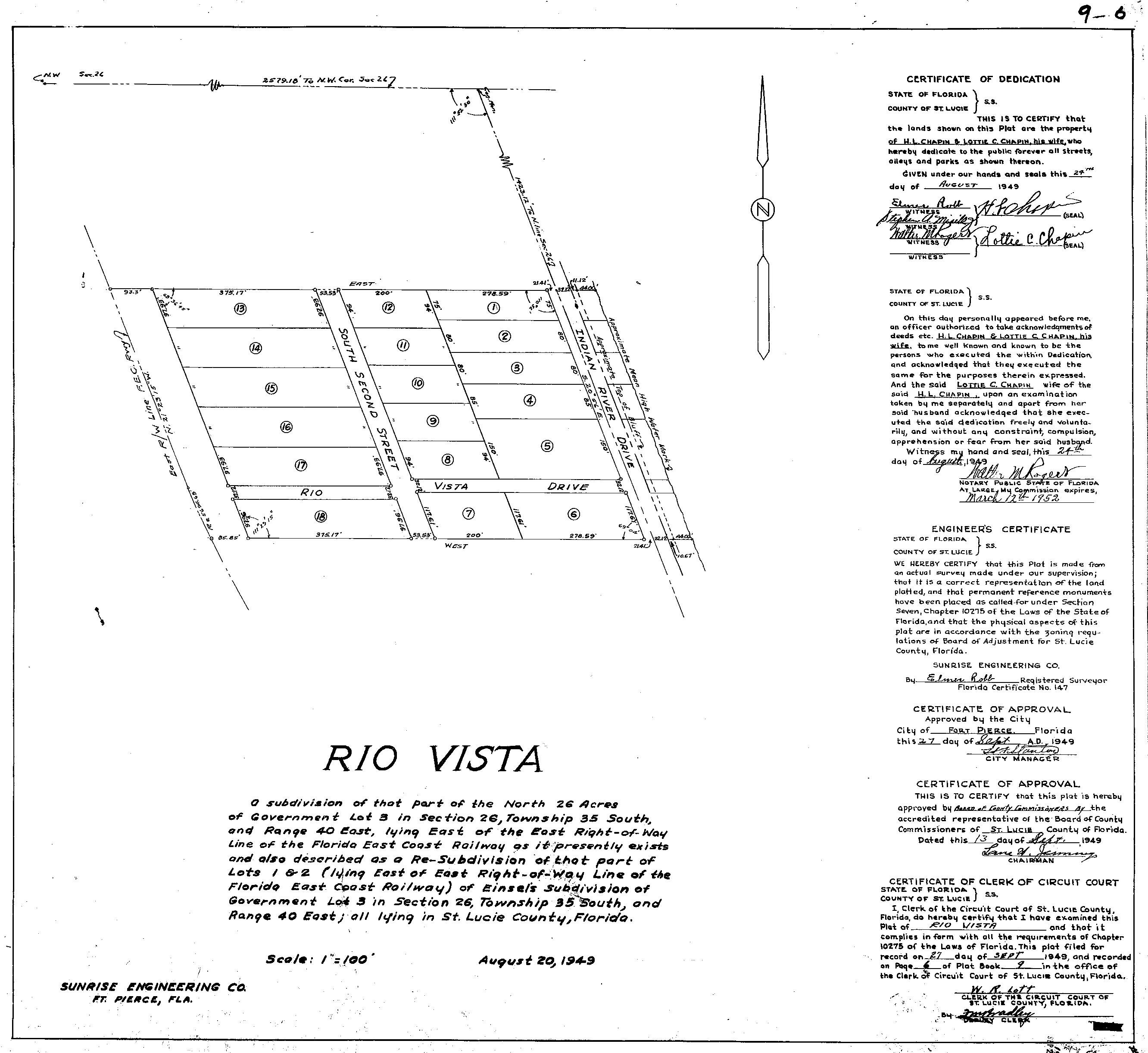
620'
|
RIO VISTA
|
9
|
6
|
1949-09-27
|
ROW width = 60.39'
|
306'
|
ELKO
|
8
|
39
|
1947-12-30
|
ROW width = 50'
|
BETWEEN Midway &
Walton Rds
|
|
|
|
|
|
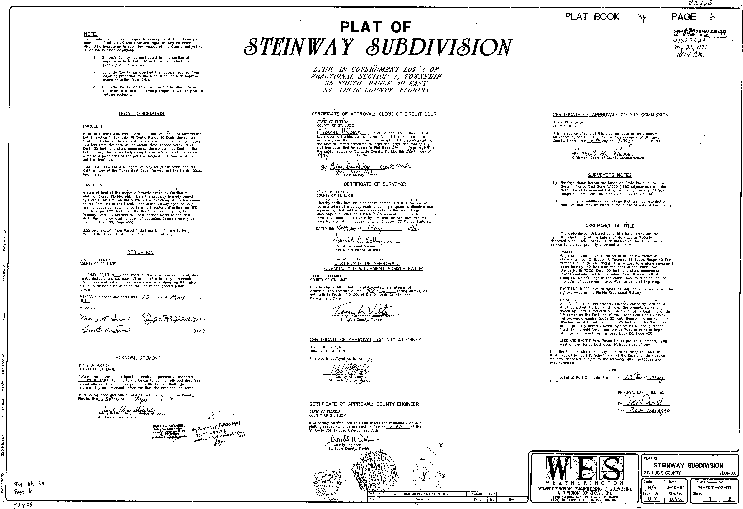
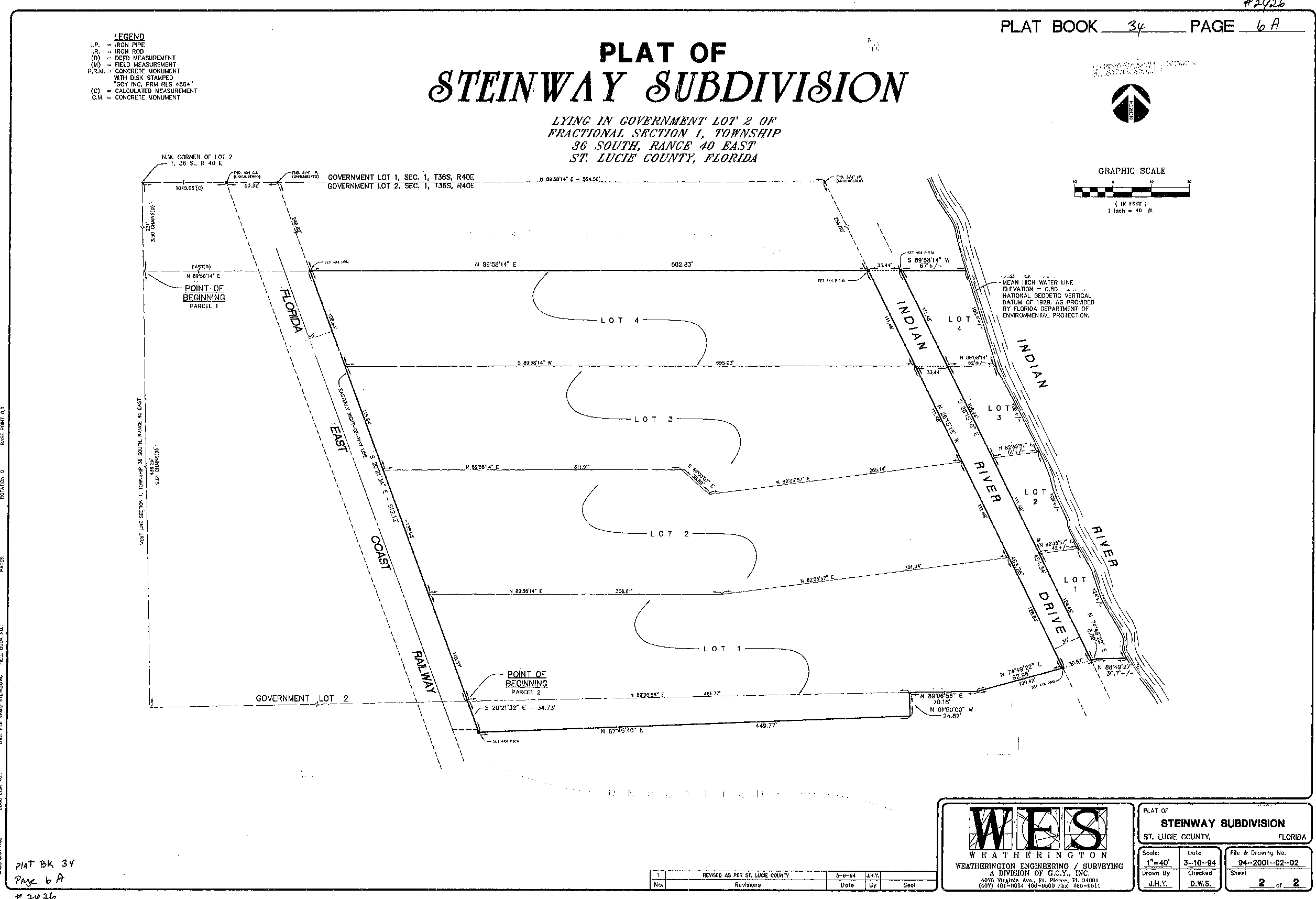
463.28'
|
STEINWAY
|
34
|
6
6A
|
1994-05-25
|
Expanded ROW width= 60'
ROW expansion is in the form of "agreements to convey"
|
794.09'
|
ENQUIST
|
8
|
37
|
1947-10-28
|
ROW width= 50'
|
599.5'
|
SAEGER'S PLACE (REV)
|
7
|
21
|
1935-07-31
|
ROW width = varies
County lands extend to waters edge
|
355.06'
|
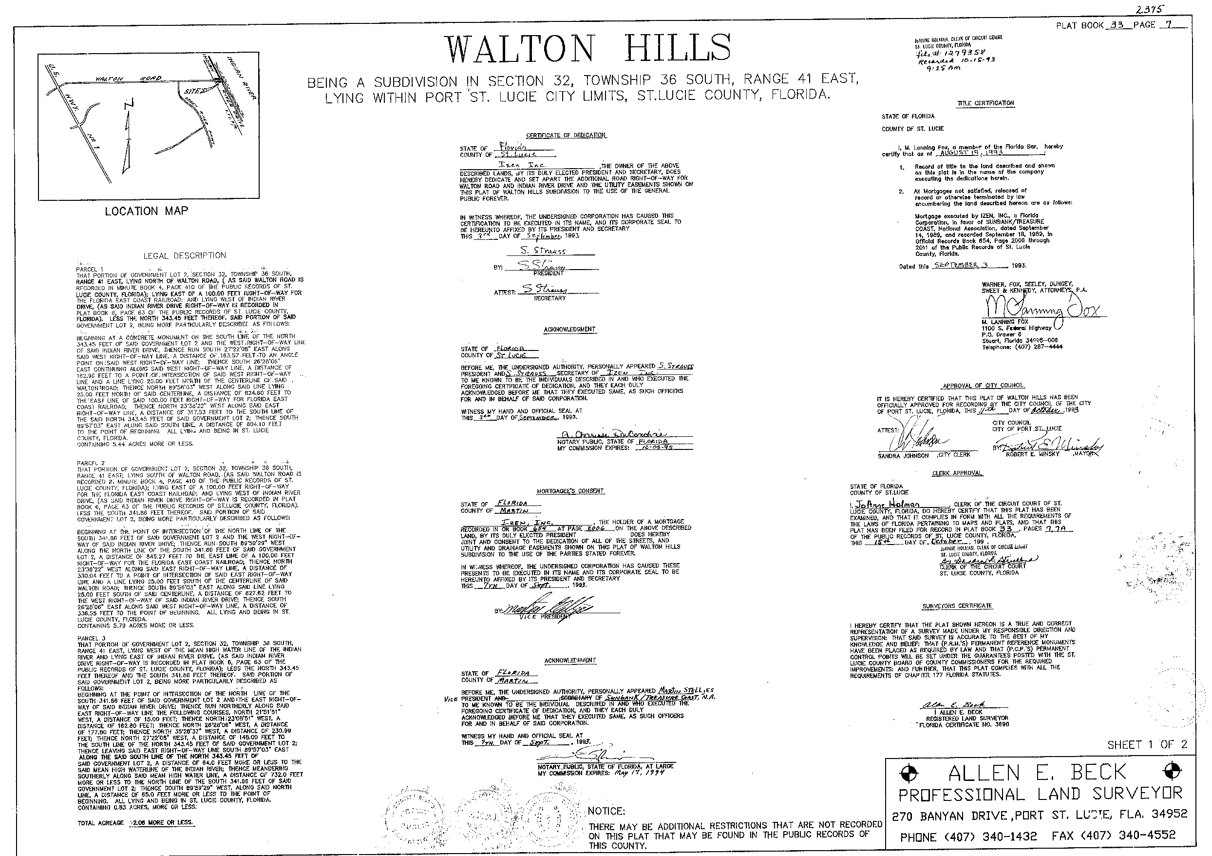
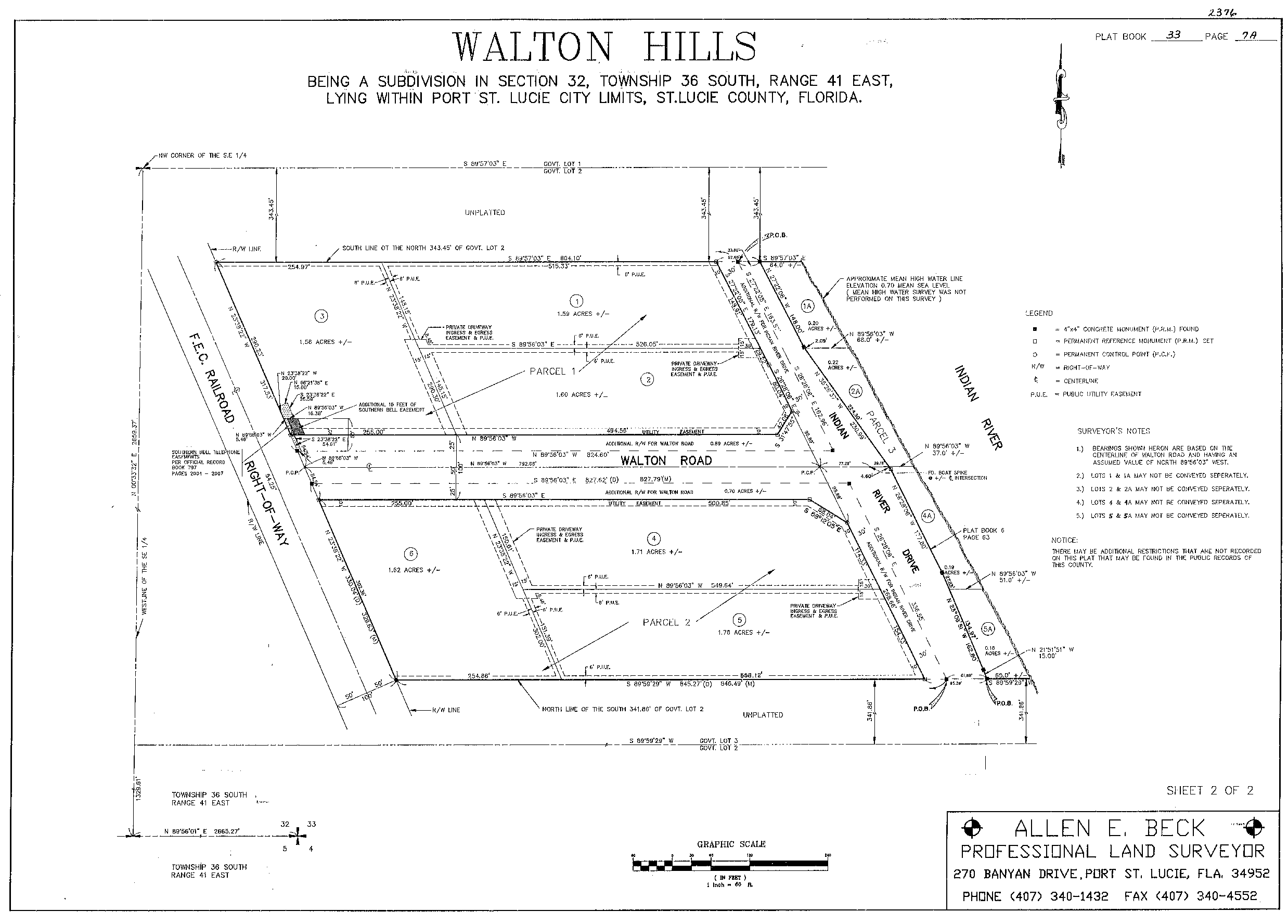
WALTON HILLS
|
33
|
7
7A
|
1993-10-15
|
ROW width = varies
|
SOUTH of Walton Rd
|
|
|
|
|
|
364.55'
|
WALTON HILLS
|
33
|
7
7A
|
1993-10-15
|
ROW width = varies
|
373.06'
|
SPRING HILL
|
10
|
10
|
1954-06-07
|
ROW width = 50'
|
196.89'
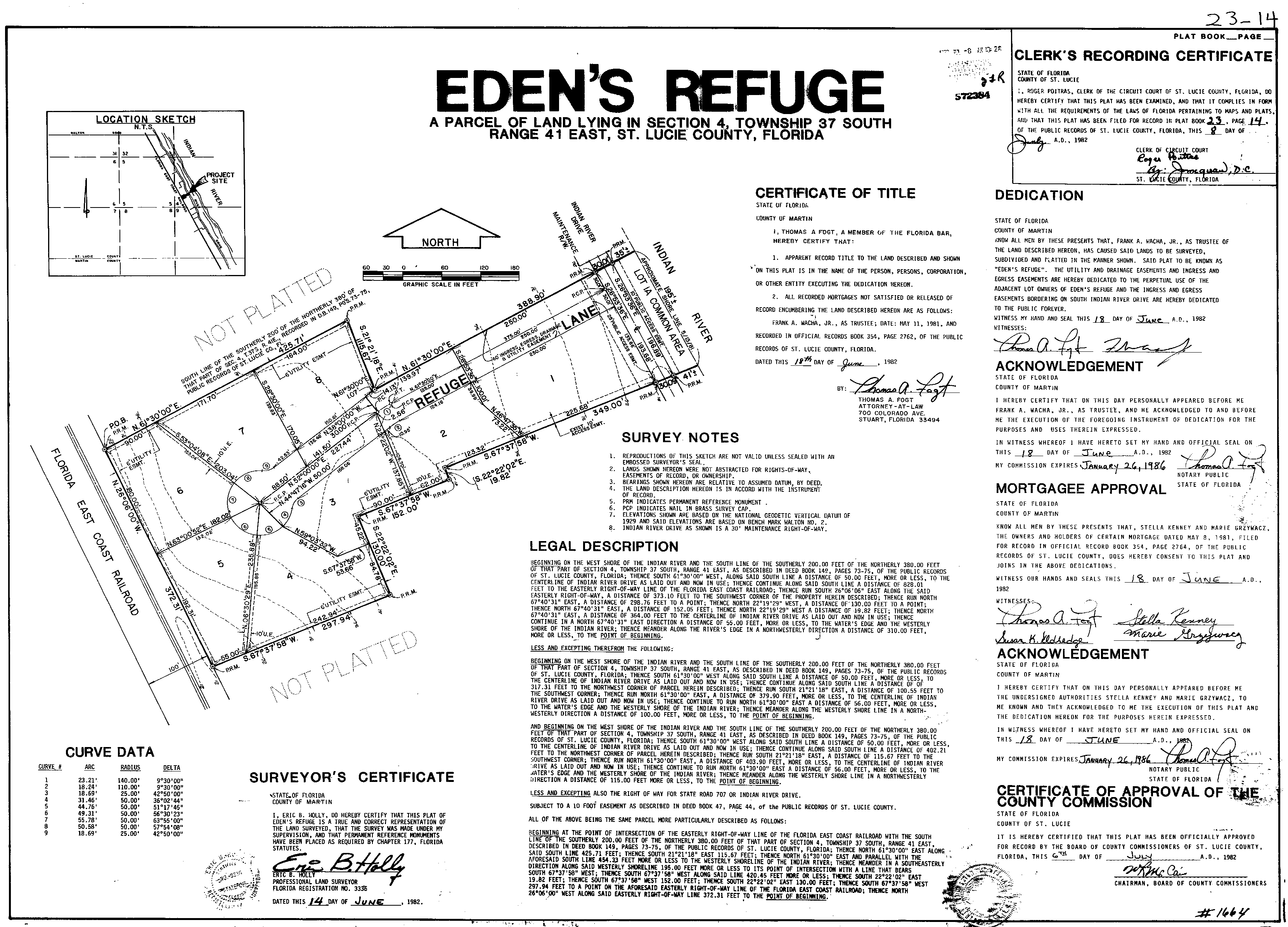
|
EDEN'S REFUGE
|
23
|
14
|
1982-07-08
|
ROW width = 65'
ROW expansion is in the form "Public Access Easements"
|
105'
|
WATER TOWER HOA
|
--
|
--
|
1992-06-22
|
ROW width = varies
County lands extend to waters edge
|
300.48'
|
PRINCESS MANOR
|
33
|
4
|
1993-08-04
|
ROW width = 60' |
709.78'
|
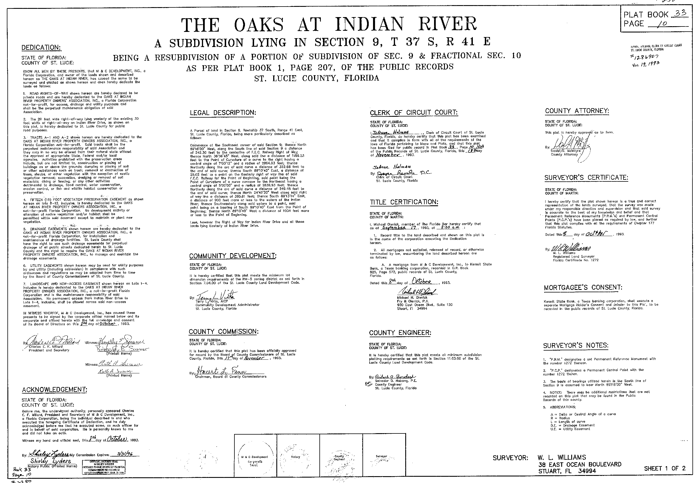
THE OAKS AT INDIAN RIVER
|
33
|
10
10A
|
1993-11-18
|
ROW width = 50'
|