![]() - 09 April 98
- 09 April 98 ![]() -
12 April 98
-
12 April 98
![]() - 09 April 98
- 09 April 98 ![]() -
12 April 98
-
12 April 98
![]() - 10 April 98 - Revised Track
Map
- 10 April 98 - Revised Track
Map
Loop1 - 3 image, 7:55 - 8:05 PM
Loop 2 - 14 image, 8:40 - 9:50
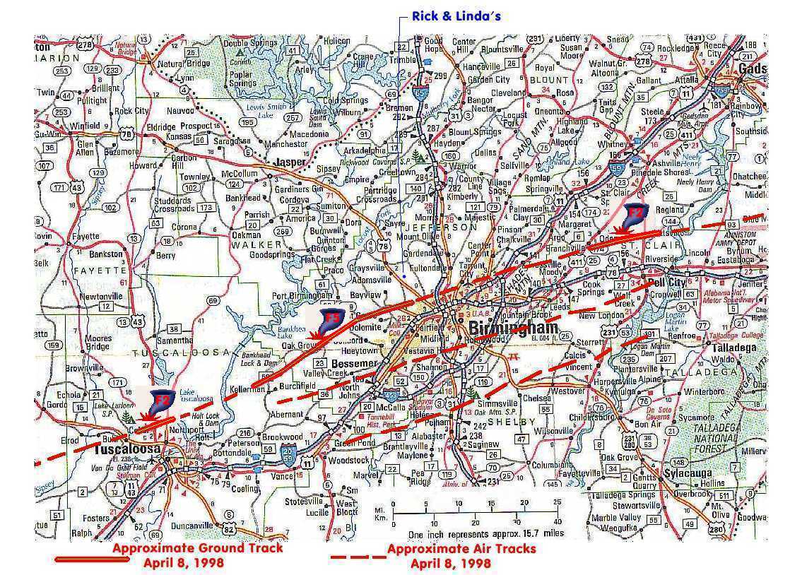
After a day full of threatening weather and watches, a devestating tornado ripped thru Tuscaloosa, Jefferson and St. Clair Counties in central Alabama. In western Jefferson County the ground track of the storm was 1/4 to 3/4 miles wide and stretched from near the Warrior River thru the communities of Oak Grove, Edgewater and Sylvan Springs. leaving a path of destruction 19 to 20 miles long in it's wake. It lifted over the Birmingham areas of Bayview, Forestdale, and North Birmingham, passed over the Birmingham airport and touched down again near Moody in Southwest St. Clair County. Intital reports include hundreds and hundreds of destroyed homes, 16 deaths in western Jefferson County and 2 in St. Clair County.
The Storm warning systems of the National Weather Service, along with the local television and radio stations are credited with saving thousands of lives. Tornado warnings had been issued at approximately 7:40 PM CDT and allowed people in the path of this deadly tornado to take shelter. The tornado that ripped thru western Jefferson County has been preliminarily classified as an "F4" tornado by the ABC 33/40 Weather team - meaning winds in the range of 206 to 260 MPH.
UPDATE
PUBLIC INFORMATION STATEMENT NATIONAL WEATHER SERVICE BIRMINGHAM AL 200 PM CDT THU APR 09 1998
...PRELIMINARY TORNADO SURVEY FOR THE APRIL 8, 1998 TORNADO ACROSS WESTERN JEFFERSON COUNTY ALABAMA, JUST WEST OF DOWNTOWN BIRMINGHAM...
...THE MOST SIGNIFICANT TORNADO TO IMPACT ALABAMA SINCE 1977, TOUCHED DOWN IN WESTERN JEFFERSON COUNTY JUST AFTER 8 PM ON APRIL 8...
NATIONAL WEATHER SERVICE METEOROLOGIST HAVE DETERMINED THAT THE TORNADO THAT RIPPED ACROSS WEST JEFFERSON COUNTY LAST NIGHT WAS AN F5 TORNADO, THE MOST VIOLENT TORNADO THAT OCCURS. F5 TORNADOES HAVE WINDS IN EXCESS OF 260 MILES PER HOUR.
THE TORNADO TRACK WAS JUST OVER 20 MILES IN LENGTH AND AT IT'S WIDEST POINT WAS ONE-HALF A MILE WIDE. THE TOUCH DOWN WAS JUST SOUTH OF THE TOWN OF SCRAP, IT TRAVELED EAST NORTHEAST IMPACTING OAK GROVE, CONCORD, PLEASANT GROVE, EDGEWATER, MCDONALD'S CHAPEL, AND ENDED IN PRATT CITY. THE STORM REACHED IT'S STRONGEST POINT NEAR THE EDGEWATER/ MCDONALD'S CHAPEL AREA.
HAD THIS TORNADO STAYED ON THE GROUND FOR AN ADDITIONAL TWO MILES THE HIGH RISES IN DOWNTOWN BIRMINGHAM WOULD HAVE BEEN HIT; FOUR MORE MILES AND THE BIRMINGHAM AIRPORT WOULD HAVE SEE THE DESTRUCTION AS WELL .
THE LATEST DEATH TOLL WITH THIS STORM IS 25, WITH MORE THAN 160 INJURIES. MORE THAN 100 HOMES WERE DESTROYED AND OVER THAN 500 HOMES HAVE SIGNIFICANT DAMAGE.
A TORNADO WARNING WAS ISSUED FOR JEFFERSON COUNTY AT 7:45 PM, GIVING RESIDENTS FROM 15 TO 30 MINUTES OF LEAD TIME.
4 PM Reports - April 9th place the fatality toll at more than 30
UPDATE
PUBLIC INFORMATION STATEMENT NATIONAL WEATHER SERVICE BIRMINGHAM AL 540 PM CDT THU APR 9 1998
...PRELIMINARY TORNADO SURVEY FOR THE APRIL 8, 1998 TORNADO ACROSS WESTERN JEFFERSON COUNTY ALABAMA, JUST WEST OF DOWNTOWN BIRMINGHAM...
THE MOST SIGNIFICANT TORNADO TO IMPACT ALABAMA SINCE 1977, TOUCHED DOWN IN WESTERN JEFFERSON COUNTY AT APPROXIMATELY 7:53 PM CDT. THE TORNADO WAS PRODUCED BY AN INTENSE THUNDERSTORM REFERRED TO BY METEOROLOGISTS AS A SUPERCELL, A LONG-LIVED THUNDERSTORM THAT FREQUENTLY PRODUCES MULTIPLE TORNADOES.
IN AN AERIAL SURVEY CONDUCTED BY NATIONAL WEATHER SERVICE METEOROLOGIST WITH THE HELP OF THE ALABAMA STATE TROOPERS AVIATION UNIT HAVE DETERMINED THAT THE TORNADO THAT RIPPED ACROSS WEST JEFFERSON COUNTY LAST NIGHT WAS AN F5 TORNADO, THE MOST VIOLENT TORNADO THAT OCCURS. F5 TORNADOES HAVE WINDS IN EXCESS OF 260 MILES PER HOUR. THE F5 TORNADO IS HIGHEST RATING FOR THE MOST VIOLENT TORNADO. THE FUJITA SCALE RUNS FROM F0 FOR THE WEAKEST TO F5 FOR THE MOST INTENSE.
THE TORNADO TRACK WAS APPROXIMATELY 21 MILES LONG AND AT IT'S WIDEST POINT WAS ONE-HALF A MILE WIDE. THE TOUCH DOWN WAS JUST SOUTH OF THE TOWN OF SCRAP, JUST INSIDE JEFFERSON COUNTY. IT TRAVELED EAST- NORTHEAST IMPACTING OAK GROVE, CONCORD, PLEASANT GROVE, EDGEWATER, MCDONALD'S CHAPEL, AND ENDED IN PRATT CITY. THE STORM REACHED IT'S STRONGEST POINT NEAR THE EDGEWATER/MCDONALD'S CHAPEL AREA.
INTERESTINGLY, THE TORNADO WAS ON A TRAJECTORY THAT IF IT HAD STAYED ON THE GROUND FOR AN ADDITIONAL TWO MILES THE HIGH RISES IN DOWNTOWN BIRMINGHAM WOULD HAVE BEEN HIT; FOUR MORE MILES AND THE BIRMINGHAM AIRPORT WOULD HAVE SEEN THE DESTRUCTION AS WELL.
THE LATEST DEATH TOLL WITH THIS STORM WAS IN THE UPPER 20S, WITH MORE THAN 160 INJURIES. MORE THAN 100 HOMES WERE DESTROYED AND MORE THAN 500 HOMES WITH SIGNIFICANT DAMAGE.
A TORNADO WARNING WAS ISSUED FOR JEFFERSON COUNTY AT 7:45 PM, GIVING RESIDENTS IN THE INITIAL TOUCHDOWN AREA 8 MINUTES WARNING AND PEOPLE TOWARD THE END OF THE 21 MILE TRACK 37 MINUTES LEAD TIME.
IN ST. CLAIR COUNTY, THE TORNADO BEGAN JUST NORTH OF MOODY AND CONTINUED ON A EAST-NORTHEAST TRACK FOR APPROXIMATELY 10 MILES. THIS TORNADO WAS RATED AS AN F2 ON THE FUJITA SCALE.
THERE WERE TWO TORNADOES IN TUSCALOOSA COUNTY. DUE TO TIME CONSTRAINTS, THOSE HAVE NOT YET BEEN SURVEYED. AN AERIAL SURVEY WILL BE CONDUCTED ON THOSE TWO TORNADOES ON FRIDAY.
BRIAN E. PETERS WARNING COORDINATION METEOROLOGIST 205-664-3010
6 PM Reports - April 9th place the fatality toll at 32
7 AM Reports - April 10th place the fatality tol1 at 38
UPDATE
The most recent estimates of the tornado damage in the Birmingham Metropolitan area
Deaths: 34 | Injured: 256 | Homes destroyed: 1,117 | Homes with >50% damage: 521 | Other Homes damaged: 467
Although we may not personally know the people - devastated by this
tornado - they are collectively our wives and husbands, daughters,
sons, and grandparents. Above all they are our friends and neighbors -
our hearts and prayers go out to each and every one touched by the fury
of this storm. To the families of those who lost their lives to this storm,
we deliver our deepest condolence.
| IN MEMORY |
|
|

One of our Birmingham TV stations, ABC 33/40, has live "Pinpoint Doppler Radar" images available in the weather portion of their web site - and a weather staff, which in our opinion, has to rate at the tops in the nation. From a little after 7:00 PM thru to midnight, they were on the air - without a commercial break - bringing full and continuous coverage of the developing storms, their track, and potential path to the viewers in their North Central Alabama coverage area. At one point, there were 13 or 14 Counties under tornado WARNINGS - with 6 or 7 tornados or potential tornadoes being tracked simutaniously!!! The live - neighborhood tracking and warning coverage was fantastic!! The management and staff of ABC 33/40 are to be commended in their commitment to the safety and information service provided to our communities. From 7:55 thru to midnight (with the exception of the period from 8:05 to 8:40 - while we took cover in the south west corner of our basement) we captured these doplar radar images from the ABC 33/40 web site.
3 Image Loop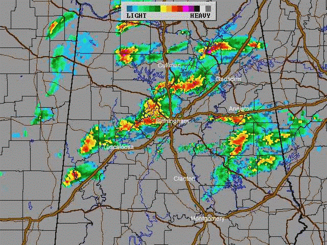 :
7:55, 8:00, 8:05 PM CDT (Animated Images 640X480 - 341Kb) In this loop
the classic "hook echo" signature of a tornado can clearly be seen moving
thru the Edgewater and Sylvan Springs area west of Birmingham. Perhaps
most impressive in this image loop is the 8:00 PM image - in which the
hook echo signature can be clearly seen - just to the left and below the
"B" in Birmingham - as well as a clearly defined circular pattern of NO
PRECIPITATION - the formation of a second tornado that passed over / thru
the Shannon and Oxmoor Valley area south of Birmingham !!!
:
7:55, 8:00, 8:05 PM CDT (Animated Images 640X480 - 341Kb) In this loop
the classic "hook echo" signature of a tornado can clearly be seen moving
thru the Edgewater and Sylvan Springs area west of Birmingham. Perhaps
most impressive in this image loop is the 8:00 PM image - in which the
hook echo signature can be clearly seen - just to the left and below the
"B" in Birmingham - as well as a clearly defined circular pattern of NO
PRECIPITATION - the formation of a second tornado that passed over / thru
the Shannon and Oxmoor Valley area south of Birmingham !!!
14 image loop - 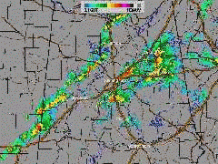 :
:
8:40 - 9:50 PM CDT (Animated Images 240 x 180 - 279 Kb) In this loop, the first storm line which contained the killer tornado is seen East of the Birmingham area moving into St. Clair County and dropping for it's second killing pass - while a second line of storms forms for it's sweep thru the area..
![]()
![]() - 12 Apr 98
- 12 Apr 98
OTHER SITES FOR INFORMATION ABOUT THIS TORNADO
National Weather Service, Birmingham - Detailed report with radar images (both reflectivity data and dopplar / wind images) and aerial photos
Mike Wilhelm - archive of ABC 33/40 radar images from 6:30PM to 9:30PM
WSI/Intellicast - 3-D Radar images of the Alabama Storms - including an animated 3-D loop
ALERT - Alabama Emergency Responce Team - including Real Audio of emergency communications provided by these HAM Radio operators during and after the storm
PLEASE consider helping if you can
-
Is coordinating a drive to assist our neighbors in need - if you
can, please make a donation. Make checks payable to"The American Red Cross"
and send them to:
P.O. Box 360039
Birmingham, AL 35236
Subject: ABC 33/40 E-Forecast
Date: Wed, 24 Mar 1999 05:44:17 -0700 (MST)
From: twc@theweathercompany.com
To: undisclosed-recipients:;@eforecast.com
ABC 33/40 E-FORECAST Morning Edition For Wednesday March 24, 1999
.... WEATHER NOTEBOOK: Would you believe there is a bit of good news about an F6 tornado?
The good news is that scientists believe an F6 will never occur. However, when the Fujita tornado scale was set up back in the '60s, provision was made for an F6. The description:
F6 Inconceivable Tornado: (winds 319-379 mph) These winds are very unlikely. The small area of damage they might produce would probably not be recognizable along with the mess produced by F4 and F5 wind that would surround the F6 winds. Missiles, such as cars and refrigerators would do serious secondary damage that could not be directly identified as F6 damage. If this level is ever achieved, evidence for it might only be found in some manner of ground swirl pattern.
Alabamas last F5 was last April 8, 1998 - in West Jefferson County. Here is the F5 profile:
Incredible Tornado (winds 261-318 mph) Strong frame houses lifted off foundations and carried considerable distances to disintegrate; automobile-sized missiles fly through the air in excess of 100 meters; trees debarked; steel reinforced concrete structures badly damaged.
Less than one percent of all tornadoes in the U. S. are F5. But they account for most of the deaths. In fact, F4 and F5 tornadoes account for 67 percent of the deaths. The weaker tornadoes (F0 and F1) make up 74% of the tornadoes but a mere 4% of the deaths. Just because we dont think its an F5, you should not let your guard down. Even an F3 can overturn JBE
J. B. Elliott ........ Matthew East
![]()
Back to | HOME | GUEST BOOK |
![]()
![]()
This page created with Netscape Navigator Gold
This page has been visited
times since adding a counter, 19:30 10 April 98.
![]()