A quick "map reading" refresher
- and Info -
About this map (& Korea maps in general)
 - 07 Sept 2001
  - 26 December 2001
- Identify YOUR Camp -
Let me know YOUR Unit's Name, Time "in country", Camp Location &
Camp Name
to add to the Camp Locator Table on the Korea Map Page
(Feedback methods are located on the MAP Page)
Back to the Map
This is a personal "50th Anniversary" of the Korean War (24 June 1950
- 27 July 1953) "project".
A great deal of information and maps are available for "the war" years.
This project is intended as an aid to remember, and honor, those many "forgotten"
and "undecorated" US soldiers who have been posted to Korea to help "hold
the line" since 1953. How many? .... My "guesstimate" (almost certainly
on the low side)... 48 years x .8 x 40,000 =~ 1.54 million "tours" !
Initially, I was still hesitant about attempting to compile and publish
this map information untill I found that the Military has essentially published
the current "order of battle" (Units, Camps, and locations) themselves!
(See this page for the current info
and links)
SECURITY and copyright NOTE: (Typical of the notes contained on
U.S. Military websites)
"... Information presented on the (military) Web site is considered
public information
and may be distributed
or copied. Use of appropriate byline/photo/image credits is requested..."
This same statement also applies to the use or republication of information
from this "Korea Trip" section of MY website.
The scans for this map were taken from a "composite"/"Northwestern"
area map that was on our company bulletin board when I arrived in 1971.
This map had been cut and pasted together from 6 different maps - scaled
at 1:50000 (known as the "15 minute" map series because the North/South
extent of them include 15 "minutes" of longitude). It's vintage is
definately "earlier" than 1967 (the vintage of maps which were "current"
when I was in country in 1971/72) and estimated to be (about) vintage 1960
- for the base map, and vintage 1965-70 for the "Camps Overlay".
This "camp locations overlay" would then be during the period that US
Forces Korea - 2nd Infantry Division occupied & defended the "Munsan
Corridor", the area which is included in this map, and the 7th Infantry
Division occupied & defended the "Chorwon" Corridor". This "appears"
to be confirmed by some "duplication" of Camp numbers along the eastern
limits of this map with the distinction being made between 2ID "camps"
and 7ID "camps" with bars either over or under the camp number. In
Early 1971 the 7th Inf Div was withdrawn from Korea. The 2nd Inf
Div was retained, their HQ relocated from Camp Howze to Camp Casey, and
their coverage area increased to include BOTH the "Munsan" and "Chorwan"
Corridors - below the Imjim River. At this same time, the ROKA assumed
primary responsibility along and South of the DMZ in this "Western Front"
- with the exception of approximately a 2Km wide strip along and either
side of MSR 1 leading to the JSA - Panmunjom.
Since the time I initially published this map, I have found an excellent
hand drawn map/sketch of the 1st Cavalry Divisions (1st Cav Div)
unit locations - in 1963/64, furnished to Ken by SP4 Julio Martinez - with
a companion listing of units and locations that does tie together that
"sketch", it's companion unit index, and the unit/camp #'s shown on my
map ...with a greater than 90% correspondance level between camp location
#'s shown in ( ) on that index and the RED ID #'s
shown on my map. These are included
on Ken Leighty's "A Tour of Duty" website in a page for the 3. TK. 15.
BL - the Turkish Armed Forces Unit which was located in my map sector CTCA
- Camp/Unit #41... this page from Ken's website is linked from both my
MAP page and that map sector page.... (be patient it's graphics rich and
slow to load).
The coloring of the roads on my posted map appears to have been done
"by hand", the RED
camp locations, the RED
Unit/Camp ID #'s,
along with the few
RED
location names appear to be printed. I'm fairly certain that the
Camp locations indicated are US Forces Camps (nad/or UN Forces) at "the
time" that this map was published but there's no doubt that the majority
have now either been abandoned or turned over to the ROKA. Also,
from feedback and conversations since posting this map it appears that
not "all" of the indicated locations were "Camps" (but most were).
The Unit identification associated with camp locations
is from feed back received. If feedback from more than one individual
identifies a location with a unit stationed there over a period of more
than "one tour", the time period for that unit, at that location, has been
revised as appropriate. An example is the ADA (HAWK Milssile Battery) Based
at Camp Warner, in map sector CSCU and thier firing base located ~ 5 Km
East at TAC 36, in map sector CSDT ... one individual identified
these locations and served there in 1962/63 ... a second individual also
identified these as his locations in 1968/69 and this unit is now identified
and associated with these locations for the period 1962/69.
NOTE: Maps can be a source of confusion as well as
being a great source for clarification and "rememberance".
Many road number designations, as well as location names and even
"hill" elevations - differ from map issue to map issue which leads to CONFUSION,
particularly among/between Vets who served in the same area - over a 50
year time span !! Since posting this map (which we'll assume
for arguments sake is vintage "1960" I have also seen maps or map segments
from areas included in my map page which were vintage 1965, 1969, and 1978
which "prove" this observation - without a doubt !! Compound this
with the fact that this "Munsan Corridor" has been occupied by five major
US Commands during this period (1953 - 2001), The 1st Marine Division,
the 24th Infantry Division, the 1st Cavalry Division, the 7th Infantry
Division, and the 2nd Infantry Division and the associated replacement
of units and movement of units within these commands from camp to camp
over time and one can easily see that some confusions can arise ... therefore
this effort can only be considered to be our collective "best recollection".
An item "of interest" on my posted map are the printed notations
on the map associated with many villages and facilities, (Destroyed)
or (Partially Destroyed) particularily in areas North of the Imjin-Gang
in and around the area which is now the "DMZ", as well as around and South
of Panmunjon. These notations, and for the greater part even
place names and building symbols, had been "cleaned up" / removed from
maps which were current in 1971 (Vintage 1965 - 67).
Included in this composite map are areas within 4 Army Map Series in
Korea - series BT, CT, BS, and CS. This "juncture point" is also
indicated on the map in the top / left hand corner. These major series
designators include areas 100Km x 100Km. Any location could then
be identified by a combination of the map series - plus - the grid coordinates,
read "right & up" - directly from the grid overlay ... with the third
grid digit "estimated". This results in a map, and ground, "location"
within 100m. (Not quite as good as the GPS positioning available
today .... but like the saying goes "Close only counts in hand gernades
and horseshoes" ... and 100 meters was "close enough" to relay fire control
adjustments .... at that time.)
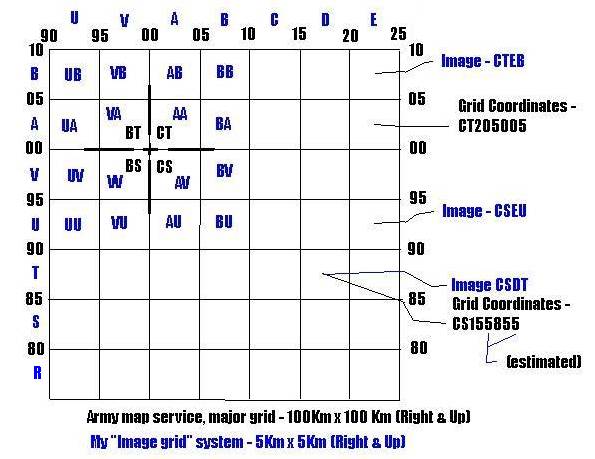
SCAN NOTES: I have scanned this map in a "supplemental" grid pattern
- 5Km x 5Km (about 3 Mi x 3 Mi). The original scans were made at
180 dpi, and the smaller images used for the "index map" were then reduced
25%. The resulting image files were saved as .jpg images with a 30%
compression setting. These scanned images, and their individual pages,
are named with a four letter file name composed of the map series designator
- BT, CT, BS, or CS ... plus ... a two letter "Image grid" designator.
Each of these "Sector Map" images are "clickable" and presented on individual
pages with the grid coordinates for the four corners indicated.
The extent of the "original (composite) map" includes the areas from
BS890630 to CT240070.
The extent of the scanned images included on my posted MAP include areas
from BS900750 to CS240070
(A "coverage area" of 34Km - East /West x
32Km North/South ... or about 20.5 Miles x 19.2 Miles)
The North limit of this map is not exactly, but very nearly - the 38th
Parallel
If you do want to identify the location of YOUR camp.... and
this project can only be a success with YOUR help...
please copy and paste the camp location (Image, coordinates,
and camp number) and add your camps name, your unit, and time in country.
FOR EXAMPLE -
Camp Howze, Image - CSBR CS084790 1, 5, & 180 - HHC
& E Co - 2nd Engr Bn - 2nd Inf Div, 71/72
Camp Edwards (East), Image - CSBS CS056832 110 - B Co - 2nd
Engr Bn - 2nd Inf Div, 71/72
Also note - it's quite likely that Camp Names may have changed during
this almost 50 year period and that unit locations are also likely to have
changed over time ... so if you do "REPORT IN" ... your unit Identification
and period in country along with the camp name are most important.
If your camp did not have a name, and many did not prior to the late 50's/early
60's, or it's location is not "flagged" on this map .... please still "Report
In" and provide what information you can.
Back to the Map